Floridae Americae Provinciae
Item Information
- Title:
- Floridae Americae Provinciae
- Description:
-
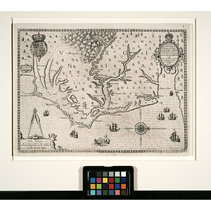
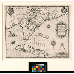
Jacques Le Moyne de Morgues, the first European artist to visit the New World, created a number of sketches and maps during his year-long stay at Fort Caroline in Florida between 1564 and 1565. After a series of Spanish raids ruined his work and disbanded the French colony, Le Moyne returned to Europe, where he continued painting naturalistic florilegia. At the request of King Charles IX, Le Moyne redrew many of his American pieces from memory, though he did not publish them. Upon Le Moyne's death in 1588, his widow sold the American paintings to Flemish engraver Theodor de Bry, who produced the copperplate engraving Americae Floridae Provinciae for his book America pt II in 1591. Americae Floridiae Provinciae delineates coastal Florida and Cuba, venturing as far north as Cape Lookout in present-day North Carolina.The extent of de Bry's alterations to Le Moyne's original map is unclear, though the engraved version of Florida contains vast inaccuracies in size and scale. De Bry latinized Le Moyne's French notes of Native tribes and geographic features, populating the map with confusing, often erroneous names. Narratives by Le Moyne and his fellow colonists note that they did not travel farther north than Lake George; however, the map extends further inland. Details such as the "Apalatci" (Appalachian) mountains, supposedly "rich in gold and silver", rely on the testimony of friendly natives. De Bry presumably included the vast stretches of land and mention of precious metals in an attempt to attract settlers and financial supporters for future colonial exploits. Despite its many inaccuracies, the map provided much-desired information about the New World during the height of the Age of Exploration. Artistically, the monochromatic map remains consistent with others published by de Bry. The engraver emphasizes coastlines and streams with intense shadowing. Sprawling forms of Florida and Cuba dominate the frame with little thought given to composition. Attributes, including the miniature trees, patterned waves, exaggerated whale, and compass rose appear nearly identical to one of de Bry's related works, Americae pars, Nunc Virginia dicta. De Bry's copperplate engraving method allows him to generate both dynamic shadows and fine linework.
- Engraver:
- Bry, Theodor de, 1528-1598
- Artist:
- Le Moyne de Morgues, Jacques, 1533?-1588
- Cartographer:
- Le Moyne de Morgues, Jacques, 1533?-1588
- Surveyor:
- Le Moyne de Morgues, Jacques, 1533?-1588
- Date:
-
1591
- Format:
-
Documents
Maps/Atlases
Prints
- Genre:
-
maps (documents)
historical maps
engravings (prints)
- Location:
- Northeastern University Library
- Collection (local):
-
Early American and European Maps
America
- Subjects:
-
Early American Maps
Age of Exploration
Discoveries in geography
- Places:
-
Florida
North Carolina
Lookout, Cape (N.C.)
South Carolina
Georgia
Appalachian Mountains
Cuba
- Link to Item:
- http://hdl.handle.net/2047/d20129091
- Terms of Use:
-
No Copyright. The organization that has made the Item available believes that the Item is in the Public Domain under the laws of the United States, but a determination was not made as to its copyright status under the copyright laws of other countries. The Item may not be in the Public Domain under the laws of other countries. Please refer to the organization that has made the Item available for more information. http://rightsstatements.org/vocab/NoC-US/1.0/
Contact host institution for more information.
- Publisher:
-
Frankfurt :
Theodore de Bry
- Identifier:
-
american_morgues_001